The eclipse of 20 April 2023
The eclipse of 20 April 2023
The first total solar eclipse in the series of five occurs on 20th of April 2023 and just touches the coast of Western Australia.
The 2023 eclipse path across the world
The central path of the 2023 eclipse starts in the Indian Ocean to the south-west of Western Australia, crosses the Australian continent in the area of North West Cape in Western Australia, then continues across the Timor Sea crossing Timor-Leste and then parts of Indonesia before finishing out in the Pacific Ocean. From Australia, the total solar eclipse can only be seen in the area of North West Cape, however the whole of Australia will experience a partial solar eclipse.
The path of this eclipse is shown in the animation of Figure 1 prepared by Michael Zeiler and Fred Espenak. Their animations can be downloaded from https://eclipsewise.com/solar/SEdecade/SEanimate2001.html#animate2021. The animation is shown from the perspective of an observer on the Moon. It shows the movement across Earth of the small black dot of the Moon’s shadow, the umbra, where a total solar eclipse will occur surrounded by the lighter penumbra where a partial solar eclipse will happen. The path of totality on the centerline is shown as a yellow line. The progress of the time in Universal Time (add eight hours for Western Australia time) is at top right and the duration of totality on the centreline at that point in the path is at bottom left.
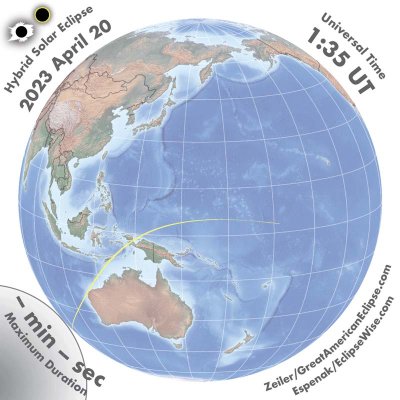
The whole path of the eclipse is a hybrid eclipse (or annular-total eclipse) where for the first approximately 650 km of the path, the Moon’s umbra does not reach Earth’s surface and an annular solar eclipse will occur. The Moon’s umbra then touches down and it becomes a total solar eclipse well before crossing Australia, Timor-Leste and Indonesia. It becomes an annular solar eclipse for the final approximately 1 000 km at the end of the path.
The 2023 solar eclipse across Australia
Figure 2 depicts the eclipse over Australia. The green lines show percentage coverage of the Sun’s diameter at eclipse maximum. This illustrates that the whole of Australia will have a partial solar eclipse and that maximum coverage of the Sun decreases with increasing distance from the path of totality. The yellow crescent images of the Sun at each of the capital cities and selected other locations show the coverage of the Sun at maximum eclipse at those places. The path of totality is shown with its centerline in blue and western and eastern extremities of totality in red. The path of totality just clips the coast of Western Australia in the area of North West Cape and this is the only location on the Australian continent where the total eclipse can be seen. Locations outside the path of totality (even just outside) will not experience any of the dramatic effects of the total eclipse.
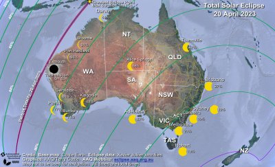
The circumstances of the eclipse at capital cities and other locations are shown in Table 1 below. Times are shown for the start of the partial phase (known as first contact or C1), time that the eclipse reaches maximum; the maximum percentage coverage of the Sun’s diameter (known as eclipse magnitude), the altitude of the Sun at eclipse maximum and the end of the partial phase (known as fourth contact or C4). All times are in local time in 24-hour clock time.
| Location | Time Zone | First Contact C1 (h:m) |
Time of Maximum (h:m) |
Eclipse Magnitude Maximum |
Altitude of Sun at Maximum |
Fourth Contact C4 (h:m) |
|---|---|---|---|---|---|---|
| Broome | AWST | 10:22 | 11:53 | 91% | 61° | 13:27 |
| Port Hedland | AWST | 10:13 | 11:41 | 95% | 58° | 13:15 |
| Karratha | AWST | 10:10 | 11:37 | 97% | 57° | 13:10 |
| Carnarvon | AWST | 10:01 | 11:25 | 96% | 51° | 12:56 |
| Geraldton | AWST | 9:59 | 11:22 | 86% | 47° | 12:51 |
| Perth | AWST | 10:00 | 11:20 | 77% | 45° | 12:47 |
| Bunbury | AWST | 9:59 | 11:19 | 74% | 43° | 12:44 |
| Kalgoorlie | AWST | 10:10 | 11:31 | 68% | 48° | 12:57 |
| Adelaide | ACST | 12:24 | 13:30 | 32% | 40° | 14:35 |
| Alice Springs | ACST | 12:13 | 13:38 | 58% | 52° | 15:02 |
| Brisbane | AEST | 13:44 | 14:45 | 27% | 32° | 15:42 |
| Canberra | AEST | 13:30 | 14:22 | 19% | 33° | 15:12 |
| Darwin | ACST | 12:18 | 13:52 | 84% | 61° | 15:25 |
| Hobart | AEST | 13:25 | 14:06 | 13% | 30° | 14:47 |
| Melbourne | AEST | 13:15 | 14:09 | 21% | 35° | 15:01 |
| Sydney | AEST | 13:37 | 14:29 | 19% | 32° | 15:19 |
| Townsville | AEST | 13:27 | 14:47 | 47% | 41° | 15:01 |
Outside the path of totality right across Australia a partial solar eclipse will occur with the Moon gradually covering part of the Sun. The view of the eclipse will start after first contact with a small “bite” taken out of the Sun. Coverage of the Sun will increase. The proportion of the Sun’s diameter covered (called the magnitude of the eclipse) will increase to a maximum and then reduce again as the Moon moves across the Sun, finishing as the Moon moves off the Sun, at fourth contact. For a detailed description of the experience see What happens during a solar eclipse.
Even though some locations in Table 1 will have a high percentage coverage of the Sun, they will not experience any of the dramatic effects of the total solar eclipse. Even at 99% coverage, the light is still up to 1 000 times brighter than in the path of totality. It is far too bright to see the corona, the chromosphere and any prominences, and you will not be enveloped by the dark shadow or see the diamond ring or the 360° sunset colours.
The 2023 total eclipse in the North West Cape area
Figure 3 shows the path of the total eclipse in the North West Cape area. The path of totality is shown with its centerline in blue and western and eastern extremities of totality in red. As shown in the left side of the figure the path of totality crosses North West Cape then north-east over several small islands off the coast near Onslow, then Barrow Island and the Monte Bello and Lowendal Islands. There is no further landfall before reaching Timor-Leste with the exception of several uninhabited sandbanks on offshore reefs (Scott, Seringapatam and Ashmore) located about 300 km off the Kimberley coast.
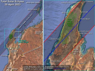
The right side of Figure 3 shows the path of totality across North West Cape including the town of Exmouth and the airport at Learmonth. The centreline of the eclipse passes between these two localities. The path covers much of the Cape Range National Park. The path of totality over the cape is about 40 km wide and about 100 km long (about 60 km on the centreline). In this area the eclipse starts as a partial solar eclipse at around 10:04 am. Totality begins at around 11:30 am with the Sun at an elevation of about 54 degrees. Totality lasts a maximum of about 60 seconds on the centreline. After totality the eclipse continues as a partial solar eclipse which ends at about 1:02 pm. The shadow of the Moon will be travelling across the ground at about 2 800km per hour. For a more detailed map of the path across North West Cape and other locations together with details of times of totality across the path see Michael Zeiler’s excellent eclipse mapping website https://www.greatamericaneclipse.com/2023-apr-20 where you can download a high-resolution map of the eclipse over North West Cape.
Circumstances of the total eclipse at selected locations on the path of totality are shown in Table 2 below including the start of the partial phase (known as first contact or C1), the start of the total phase (known as second contact or C2), the duration of the total phase, the altitude of the Sun for the total phase and the end of the final partial phase (known as fourth contact or C4). All times are in Australian Western Standard Time (AWST) in 24-hour clock time.
| Location | First Contact C1 (h:m) | Start of Totality C2 (h:m:s) | Duration of totality (m:s) | Altitude of Sun at totality | Fourth Contact C4 (h:m) |
|---|---|---|---|---|---|
| Exmouth | 10:04 | 11:29:48 | 00:53 | 54° | 13:03 |
| Learmonth airport | 10:04 | 11:29:15 | 00:55 | 54° | 13:02 |
| Main road at centreline | 10:04 | 11:29:26 | 01:00 | 54° | 13:02 |
| Communications base | 10:05 | 11:30:07 | 00:42 | 54° | 13:03 |
| Yardie Creek | 10:04 | 11:28:39 | 00:59 | 54° | 13:01 |
| Barrow Island | 10:08 | 11:33:50 | 00:59 | 56° | 13:07 |
| Ningaloo Station | 10:03 | 11:27:56 | 00:47 | 53° | 13:00 |
Eclipse circumstances at other locations
To find the circumstances of the 2028 eclipse at any other location, either on the path of totality or not, use Xavier Jubier’s interactive Google map for the eclipse at: http://xjubier.free.fr/en/site_pages/solar_eclipses/HSE_2023_GoogleMapFull.html. A map will display the path of totality across Earth. Enter the place name in the search box and select from the list or find the location on the map and select it. An information box will pop up with the details of the eclipse at that point.
What to see during totality for the 2023 eclipse
As totality approaches, the temperature will gradually decrease and the light will fade, confusing birds and animals. In the last few minutes, the Moon’s shadow may be seen in the south-west. As this is a short eclipse and the Sun will be high in the sky, the shadow will not be as dark as with other eclipses and may appear as a thunderstorm approaching swiftly and silently from the south-west.
A wind may spring up, and it may feel as if there is a chill in the air. Viewing through your safe solar filters, if the sky is clear, you can see the very thin crescent shape of the Sun decreasing to the last few points of light shining through valleys around the edge of the Moon, then winking out as the surrounding light suddenly goes dark.
Removing your safe solar filters, you will see the dramatic sight of the eclipsed Sun appearing as a black hole in the sky surrounded by the Sun’s beautiful white corona. Initially there will be an arc of the Sun’s bright red chromosphere and there may be prominences visible. As this will be a relatively short eclipse because of the close match in size between the Sun and Moon, the bonus is usually a greater spectacle of the chromosphere extending in a larger colourful arc around the Sun and prominences may appear at any point around the Sun and last for the whole of the eclipse.
When totality arrives, the whole sky will become a much darker blue, resembling a deep twilight. Planets and bright stars will become visible if the sky is clear. The sight of the Sun in the sky surrounded by the planets, extending in a line out from the Sun, gives a unique perspective of the Solar System, as the planets move in their orbits all on almost the same plane.
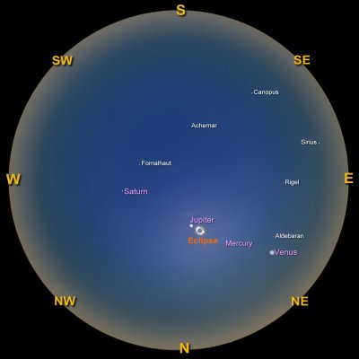
A simulated view of the whole sky created from the program Stellarium for the time of totality from North West Cape is shown in Figure 4. View this chart as if holding it overhead. The eclipsed Sun will be relatively high in the northern sky. Jupiter will be just to the left of the Sun. Venus will be lower down in the north-east sky. Mercury will be between the Sun and Venus. Saturn will be higher in the western sky. Bright stars may also be visible in the locations shown. There will be sunset-like colours all around the horizon. See What happens during a solar eclipse for more detailed information and photos of the effects and light and colours in the atmosphere for an explanation of the horizon sunset colours.
Towards the end of totality another bright red arc of chromosphere will appear. Then, all too quickly at the end of totality, the first point of sunlight will burst through a valley around the edge of the Moon in the dramatic and memorable finale – the Diamond Ring effect. After seeing the Diamond Ring effect, safe solar filters must be used immediately to enjoy the remainder of the eclipse as a partial eclipse.
Safe viewing of the 2023 solar eclipse
The only safe way to look directly at the uneclipsed, or partially eclipsed Sun is through special-purpose solar filters, such as “eclipse glasses” or handheld solar viewers. However, it is vital that they conform to the correct standard, and that they are used safely.
Here are tips to assist in the safe use of eclipse glasses and similar products:
- The filters must be certified to comply with the requirements of the ISO 12312-2 international standard. It is strongly recommended that they be purchased from reputable vendors to ensure that they have been correctly certified. These may include astronomy supply shops, public observatories and planetariums or from a government agency. Ordering from other suppliers especially on the internet is not recommended as the filters may not be correctly certified.
- Always inspect your solar filter before use; if scratched, punctured, torn, or otherwise damaged, discard it. Read and follow any instructions printed on or packaged with the filter.
- Always supervise children using solar filters, ensuring that they use them correctly and do not sneak a peek at the Sun around the filter.
- If you normally wear eyeglasses for distance viewing, keep them on. Put your eclipse glasses on over them or hold your handheld viewer in front of them.
- Stand still and cover your eyes with your eclipse glasses or solar viewer before looking up at the bright Sun. After looking at the Sun, turn away and then remove your filter - do not remove it while looking at the Sun.
- Do not look at the uneclipsed, or partially eclipsed Sun through an unfiltered camera, telescope, binoculars, or other optical device.
- Similarly, do not look at the Sun through a camera, telescope, binoculars, or any other optical device while using your eclipse glasses or handheld solar viewer - the concentrated solar rays could damage the filter and enter your eye(s), causing serious injury.
Other methods of experiencing the partial phases of the eclipse are by viewing a projected image of the Sun. This can be safe because no one is looking directly at the Sun. This includes pinhole projection, mirror projection, binocular or telescope projection or commercially produced projection devices. For details of these methods and how to use them safely and other eye safety information see Eye Safety.
It is safe, and awe-inspiring, to watch the eclipse without using eye protection during the brief period of totality, while the Moon is completely covering the Sun – that is the excitement of this event! However, you must be sure that you are watching at the correct time and place and are in totality. Refer to Figure 3 and Table 2 above to check where to be and when. If you are inside the path of totality, remove your solar filter only when the Moon completely covers the Sun’s bright face, and it suddenly becomes dark. Wait until the last bright spots around the edge of the Sun as viewed through your filter have disappeared. Experience totality, then, as soon as the bright Sun begins to reappear in the “diamond ring”, look away or replace your solar viewer to watch the remaining partial phases. It should be noted that certified “eclipse glasses” and filters are intended to be used for the partial phases of the eclipse. They MUST be removed to experience totality. If using the pinhole method to watch the progress of the eclipse, be aware that it cannot be used to determine the start of totality as the image will fade out well before the start of totality and viewing with a properly certified solar filter is a more effective method.
Weather prospects for the 2023 total eclipse
Weather on the day of the eclipse cannot be predicted far in advance of the time of the eclipse. However, statistics of climate observations can give an indication of average weather. Statistics taken from observations at Learmonth Airport over many years set the number of cloudy days in the month at 6.5 and the number of clear days at 14.6, with the rest lying somewhere in between. A clear day is defined as one in which the average of the 9 am and 3 pm cloud cover observations is 25 percent or less; a cloudy day has an average of 75 percent or more cloud cover observations at the two times. When all of the days of the month are lumped together, the average cloudiness at Exmouth is around 40 percent at 9 am and 3 pm.
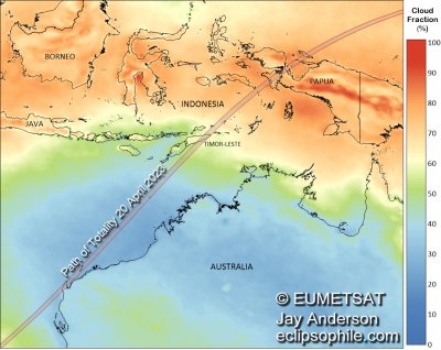
An excellent resource for eclipse weather is Jay Anderson’s eclipse weather website which has information on weather for the 2023 eclipse at https://eclipsophile.com/hse2023/. Figure 5 is from that site and shows the mean April cloud cover as measured by satellite over a 20-year period. The lowest cloud amounts are in the Australian region and the Timor Sea with North West Cape in the 30 to 36 percent range of cloud cover.
Despite the encouraging statistics, there is always the possibility of cloud on the day. There is also the possibility of a cyclone, but April is at the end of the cyclone season.
Overall, it could be interpreted that there is a reasonable to moderate chance of the total eclipse being cloud free in Australia.
Where to observe the 2023 total eclipse
Access to the North West Cape area
North West Cape is in a relatively remote part of Western Australia. By road, Exmouth is about 1 250 km from Perth, 3 200 km from Darwin and about 1 400 km from Broome. Apart from the last 220 km, access is via National Highway 1, a good 2 lane (one either direction) sealed road, with services spaced at irregular intervals. If driving these distances, you would be wise to be relatively self-sufficient carrying adequate fuel, food and water and allowing for contingencies.
From National Highway 1, the Minilya Exmouth road is a reasonably good condition sealed two lane road (one either direction) to Exmouth. Be aware that there is likely to be a lot of traffic on this road and in the Exmouth area and there may well be congestion around the time of the eclipse. There are regular flights to Learmonth airport from Perth and there may be additional charter flights arranged around the time of the eclipse. Searching on the internet will locate a number of operators offering tours to the area to see the eclipse. Established accommodation in the area has generally been booked out for some time but the Shire of Exmouth may make temporary accommodation available.
North West Cape total eclipse area
The topography of the Cape consists of the Cape Range with elevations up to about 300 metres and generally flat terrain on the eastern side and to a lesser extent on the western side of the cape. The centreline of the path of totality passes between Learmonth airport and the town of Exmouth.
The Minilya Exmouth road (see figure 3 right side) gives access to the eastern side of the Cape. The road continues on past Exmouth as a sealed road to pass the Harold E Holt communications station and continues on down the west coast to Yardie Creek. There is access into the Cape Range National Park from both the east side and the west side although many roads are suitable only for a 4-wheel drive vehicle. The eclipse occurs high in the sky so there are many locations that will be suitable for eclipse viewing. The beaches on both the east side and the west side of the cape are likely to be popular locations. The gorges and hills in the Cape Range National Park may provide an interesting foreground for photographers. See Eclipse Photography for advice on taking photos of the eclipse.
The Exmouth Shire Council is understood to be setting up one or more possible viewing sites with facilities. See the website https://ningalooeclipse.com. The duration of totality will be greatest closer to the centreline but anywhere in the path will provide a spectacular view. Those experiencing their first total eclipse are advised to be well inside the path limit lines.
Islands off the coast of Onslow.
Some of these islands are inhabited, and it is understood that options are being proposed for transport to the islands for the eclipse from Onslow. Contact the Shire of Ashburton for further information.
Cruise ship
At least one cruise ship is planned to be in the area of Exmouth for observation of the total eclipse. It may have the benefit of moving prior to the time of the total eclipse to avoid any local cloud. Contact P&O Cruises for more information.
Barrow Island and the Montebello Islands
Barrow Island is a Class A Nature reserve and a gas facility and there is normally no tourist access allowed.
The Montebello Islands is the location of British atomic bomb tests in the 1950’s. In the past fishing charters have been arranged to this general area out of Karratha.
