The eclipse of 22 July 2028
The eclipse of 22 July 2028
The second total solar eclipse in the series of five occurs on 22nd of July 2028 and crosses the Australian continent from Western Australia through to New South Wales, passing directly over Sydney.
The 2028 eclipse path across the world
The path of totality of the 2028 eclipse starts in the Indian Ocean to the west of Indonesia, crosses the Australian territories of Cocos and Keeling Islands and Christmas Island and makes contact with the Australian mainland firstly in the Kimberley area of Western Australia, then continues across the Northern Territory, south-west Queensland and into New South Wales passing directly over the Sydney area. Continuing across the Tasman Sea the path crosses New Zealand over Queenstown and Dunedin finishing out in the Pacific Ocean.
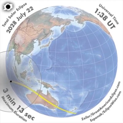
The whole of Australia and New Zealand will experience a partial solar eclipse. The path of the eclipse is shown in the animation of Figure 1 prepared by Michael Zeiler and Fred Espenak. Their animations can be downloaded from https://eclipsewise.com/solar/SEdecade/SEanimate2001.html#animate2021. The animation is shown from the perspective of an observer on the Moon. It shows the movement across Earth of the small black dot of the Moon’s shadow, the umbra, where a total solar eclipse will occur, surrounded by the lighter penumbra where a partial solar eclipse will happen. The path of totality is shown as a yellow line. The progress of the time in Universal Time is at top right and the duration of totality on the centerline at that point in the path is at bottom left. To convert Universal time to local time, add 6:30 for Cocos (Keeling) islands; 7:00 for Christmas Island; 8:00 for Western Australia; 9:30 for South Australia, Northern Territory and Broken Hill; 10:00 for eastern Australian states; and 12:00 for New Zealand.
The 2028 solar eclipse across Australia
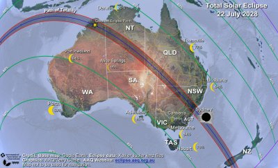
Figure 2 depicts the eclipse over Australia and New Zealand. The green lines show percentage coverage of the Sun’s diameter at eclipse maximum. This illustrates that the whole of Australia and New Zealand will have a partial solar eclipse and that maximum coverage of the Sun decreases with increasing distance from the path of totality. The yellow crescent images of the Sun at each of the capital cities and selected other locations show the coverage of the Sun at maximum eclipse at those places. The path of totality is shown with its centerline in blue and northern and southern extremities of totality in red. The path of totality crosses Western Australia, Northern Territory, Queensland and New South Wales as well as New Zealand. Locations outside the path of totality (even just outside) will not experience any of the dramatic effects of the total eclipse.
Circumstances of the eclipse at capital cities and other locations are shown in Table 1 below. Times are shown for the start of the partial phase (known as first contact or C1), time that the eclipse reaches maximum, the maximum percentage coverage of the Sun’s diameter (known as eclipse magnitude), the altitude of the Sun at eclipse maximum, and the end of the partial phase (known as fourth contact or C4). All times are in local time in 24-hour clock time.
| Location | Time Zone | First Contact C1 (h:m) |
Time of Maximum (h:m) |
Eclipse Magnitude Maximum |
Altitude of Sun at Maximum |
Fourth Contact C4 (h:m) |
|---|---|---|---|---|---|---|
| Adelaide | ACST | 11:48 | 13:11 | 80% | 34° | 14:29 |
| Alice Springs | ACST | 11:22 | 12:53 | 95% | 46° | 14:20 |
| Ackland | NZST | 15:18 | 16:24 | 74% | 10° | 17:23 |
| Brisbane | AEST | 12:41 | 14:02 | 84% | 33° | 15:14 |
| Canberra | AEST | 12:38 | 13:59 | 96% | 29° | 15:13 |
| Darwin | ACST | 10:59 | 12:32 | 90% | 57° | 14:03 |
| Hobart | AEST | 12:40 | 13:56 | 78% | 23° | 15:07 |
| Melbourne | AEST | 12:32 | 13:53 | 84% | 29° | 15:07 |
| Perth | AWST | 09:30 | 10:47 | 59% | 33° | 12:08 |
| Port Hedland | AWST | 09:13 | 10:40 | 84% | 44° | 12:12 |
| Townsville | AEST | 12:20 | 13:46 | 77% | 45° | 15:03 |
| Wellington | NZST | 15:16 | 16:22 | 85% | 8° | 17:23 |
Outside the path of totality right across Australia a partial solar eclipse will occur with the Moon gradually covering part of the Sun. The view of the eclipse will start after first contact with a small “bite” taken out of the Sun. Coverage of the Sun will increase. The proportion of the Sun’s diameter covered (called the magnitude of the eclipse) will increase to a maximum and then reduce again as the Moon moves across the Sun, finishing as the Moon moves off the Sun at fourth contact. For a detailed description of the experience see What happens during a solar eclipse.
Even though some locations in Table 1 will have a high percentage coverage of the Sun, they will not experience any of the dramatic effects of the total solar eclipse. Even at 99% coverage, the light is still up to 1 000 times brighter than in the path of totality. It is far too bright to see the corona, the chromosphere and any prominences and you will not be enveloped by the dark shadow or see the diamond ring or the 360° sunset colours.
The 2028 eclipse path of totality
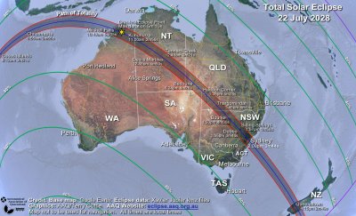
Figure 3 provides details of the path of totality across Australia and New Zealand. The path of totality is shown with its centerline in blue and northern and southern extremities of totality in red. For selected locations on the path of totality the start time of totality (in local time) is shown as well as the duration of totality. The greatest eclipse point is the location where the duration of totality is longest. For this eclipse it is in the Kimberley region of Western Australia (shown on Figure 3) with a duration of 5 minutes and 10 seconds. This is a relatively long eclipse. The width of the path of totality varies between about 230 km in Western Australia to about 190 km near Sydney and about 170 km in New Zealand. The shadow of the Moon will be travelling across the ground at about 2 150 km per hour in Western Australia increasing to about 4 900 km per hour near Sydney.
The 2028 eclipse path of totality in the Sydney region
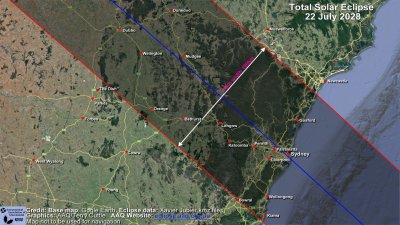
Details of the path of totality in the Sydney region are shown in Figure 4. As before, the path of totality is shown with its centerline in blue and northern and southern extremities of totality in red. The path covers several major towns and cities as well as the greater Sydney area. The area has a population of about 6 million residents. Although “the dish” near Parkes is just outside the path, the Siding Springs Observatory (not shown in the diagram) is inside the path.
Circumstances for locations in the 2028 eclipse path of totality
Circumstance of the total eclipse at selected locations on the path of totality are shown in Table 2 below including the start of the partial phase (known as first contact or C1), the start of the total phase (known as second contact or C2), the duration of the total phase, the altitude of the Sun for the total phase, and the end of the final partial phase (known as fourth contact or C4). All times are in local time in 24 hour clock time.
| Location | Time Zone | First Contact C1 (h:m) |
Start of Totality C2 (h:m:s) |
Duration of totality (m:s) |
Altitude of Sun at Maximum |
Fourth Contact C4 (h:m) |
|---|---|---|---|---|---|---|
| Cocos (Keeling) Islands | CCT | 7:04 | 8:11:59 | 3:21 | 24° | 9:35 |
| Christmas Island | CXT | 7:40 | 8:54:40 | 3:55 | 35° | 10:25 |
| Mitchell falls, WA | AWST | 9:19 | 10:49:05 | 5:05 | 53° | 12:25 |
| Kununurra, WA | AWST | 9:28 | 10:59:32 | 2:56 | 53° | 12:33 |
| Tennant Creek, NT | ACST | 11:17 | 12:47:53 | 3:21 | 50° | 14:17 |
| Devils Marbles, NT | ACST | 11:18 | 12:48:25 | 4:50 | 49° | 14:18 |
| Stuart highway Centreline, NT | ACST | 11:18 | 12:48:24 | 4:50 | 49° | 14:18 |
| Bedourie, QLD | AEST | 12:06 | 13:33:59 | 4:28 | 44° | 14:59 |
| Haddon corner, QLD | AEST | 12:12 | 13:38:26 | 4:24 | 42° | 15:02 |
| Thargomindah, QLD | AEST | 12:21 | 13:45:14 | 4:14 | 38° | 15:06 |
| Bourke, NSW | AEST | 12:27 | 13:50:06 | 4:00 | 35° | 15:09 |
| Siding Springs, NSW | AEST | 12:35 | 13:56:36 | 1:58 | 33° | 15:13 |
| Gilgandra, NSW | AEST | 12:34 | 13:55:11 | 3:52 | 32° | 15:12 |
| Dubbo, NSW | AEST | 12:35 | 13:55:17 | 3:46 | 32° | 15:12 |
| Penrith, NSW | AEST | 12:40 | 13:58:45 | 3:40 | 29° | 15:14 |
| Parramatta, NSW | AEST | 12:40 | 13:59:12 | 3:44 | 29° | 15:14 |
| Sydney, NSW | AEST | 12:41 | 13:59:30 | 3:44 | 29° | 15:15 |
| Gosford, NSW | AEST | 12:41 | 13:59:45 | 3:16 | 29° | 15:15 |
| Wollongong, NSW | AEST | 12:40 | 13:59:36 | 2:51 | 29° | 15:14 |
| Queenstown, NZ | NZST | 15:07 | 16:15:05 | 2:49 | 10° | 17:20 |
| Dunedin, NZ | NZST | 15:09 | 16:15:47 | 2:47 | 8° | 17:20 |
Eclipse circumstances at other locations
To find the circumstances of the 2028 eclipse at any other location both inside and outside the path of totality, use Xavier Jubier’s interactive Google map for the eclipse at: http://xjubier.free.fr/en/site_pages/solar_eclipses/TSE_2028_GoogleMapFull.html. A map will display the path of totality across Earth. Enter the place name in the search box and select from the list or find the location on the map and select it. An information box will pop up with the details of the eclipse at that point.
What to see during totality for the 2028 eclipse
As totality approaches the temperature will gradually decrease and the light will fade, confusing birds and animals. In the last few minutes, the Moon’s shadow may be seen approaching. As this is a long eclipse with a wide path the shadow may be well defined and is likely to appear as a very dark thunderstorm approaching swiftly and silently from a generally north-west direction. In Western Australia the umbra will reach down to Earth somewhat vertically but towards Sydney and the end of the path near New Zealand, the shadow will become more inclined and this is likely to make it more defined and darker.
A wind may spring up, and it may feel as if there is a chill in the air. Viewing through your safe solar filters, if the sky is clear, you can see the very thin crescent shape of the Sun decreasing to the last few points of light shining through valleys around the edge of the Moon then winking out as the surrounding light suddenly goes dark.
Removing your safe solar filters, you will see the dramatic sight of the eclipsed Sun appearing as a black hole in the sky surrounded by the Sun’s beautiful white corona. Initially, there will be an arc of the Sun’s bright red chromosphere and there may be prominences visible. The extent of the chromosphere and how long any prominences last will depend on where you are across the path of totality. Near the centre of the path, the chromosphere and any prominences may only be seen briefly as they are covered by the moving Moon. Towards either side of the path expect the chromosphere to appear more down one side of the Sun and last longer and prominences on that side of the Sun will also likely last longer.
When totality arrives, the whole sky will become a very dark blue, resembling a deep twilight as you are surrounded by the Moon’s shadow. Planets and bright stars will become visible if the sky is clear. As this is a relatively long eclipse the sky will be darker than shorter eclipses and more stars and planets would be expected to be visible if the sky is clear. The sight of the Sun in the sky surrounded by the planets, extending in a line out from the Sun, gives a unique perspective of the Solar System as the planets move in their orbits all on almost the same plane.
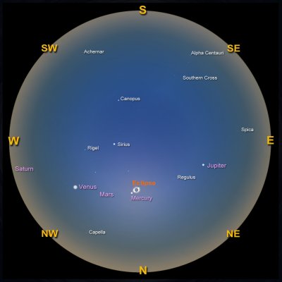
Figure 5 is a simulation created using the software program Stellarium of a view of the whole sky as seen from Devils Marbles in the Northern Territory during totality. View this chart as if holding it overhead. The eclipsed Sun will be reasonably high in the sky. To the north, the bright planet Venus will be to the left of the Sun in the north-west. Jupiter will be to the right of the Sun in the north-east. Mercury will be close to the Sun about 4 degrees to the left and down and Mars will be between Venus and the Sun. Bright stars may be visible in the locations shown. There will be sunset-like colours 360 degrees all around the horizon. See What happens during a solar eclipse for more detailed information and photos of the effects and Light and colours in the atmosphere for an explanation of the horizon sunset colours.
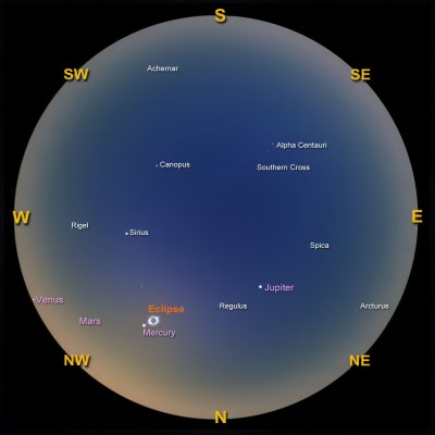
As the eclipse progresses towards the east of Australia, the Sun will be further to the west as will be the planets and the stars. Figure 6 is a simulation created using the software program Stellarium of a view of the whole sky as seen from Sydney during totality. The eclipse will be lower in the north-west. Venus will be on the western horizon and Jupiter will be higher in the sky. Stars will generally be further to the west.
Towards the end of totality another bright red arc of the chromosphere will appear. Then, all too quickly, at the end of totality, the first point of sunlight will burst through a valley around the edge of the Moon in the dramatic and memorable finale – the diamond ring effect. After seeing the diamond ring, safe solar filters must be used immediately to enjoy the remainder of the eclipse as a partial eclipse.
Safe viewing of the 2028 solar eclipse
The only safe way to look directly at the uneclipsed, or partially eclipsed Sun is through special-purpose solar filters, such as “eclipse glasses” or handheld solar viewers. However, it is vital that they conform to the correct standard, and that they are used safely.
Here are tips to assist in the safe use of eclipse glasses and similar products:
- The filters must be certified to comply with the requirements of the ISO 12312-2 international standard. It is strongly recommended that they be purchased from reputable vendors to ensure that they have been correctly certified. These may include astronomy supply shops, public observatories and planetariums or from a government agency. Ordering from other suppliers especially on the internet is not recommended as the filters may not be correctly certified.
- Always inspect your solar filter before use; if scratched, punctured, torn, or otherwise damaged, discard it. Read and follow any instructions printed on or packaged with the filter.
- Always supervise children using solar filters, ensuring that they use them correctly and do not sneak a peek at the Sun around the filter.
- If you normally wear eyeglasses for distance viewing, keep them on. Put your eclipse glasses on over them or hold your handheld viewer in front of them.
- Stand still and cover your eyes with your eclipse glasses or solar viewer before looking up at the bright Sun. After looking at the Sun, turn away and then remove your filter - do not remove it while looking at the Sun.
- Do not look at the uneclipsed, or partially eclipsed Sun through an unfiltered camera, telescope, binoculars, or other optical device.
- Similarly, do not look at the Sun through a camera, telescope, binoculars, or any other optical device while using your eclipse glasses or handheld solar viewer - the concentrated solar rays could damage the filter and enter your eye(s), causing serious injury.
Other methods of experiencing the partial phases of the eclipse are by viewing a projected image of the Sun. This can be safe because no one is looking directly at the Sun. This includes pinhole projection, mirror projection, binocular or telescope projection or commercially produced projection devices. For details of these methods and how to use them safely and other eye safety information see Eye Safety.
It is safe, and awe-inspiring, to watch the eclipse without using eye protection during the brief period of totality, while the Moon is completely covering the Sun – that is the excitement of this event! However, you must be sure that you are watching at the correct time and place and are in totality. Refer to Figures 3 and 4 and Table 2 above to check where to be and when. If you are inside the path of totality, remove your solar filter only when the Moon completely covers the Sun’s bright face, and it suddenly gets quite dark. Wait until the last bright spots around the edge of the Sun as viewed through your filter have disappeared. Experience totality, then, as soon as the bright Sun begins to reappear in the “diamond ring”, look away or replace your solar viewer to watch the remaining partial phases. It should be noted that certified “eclipse glasses” and filters are intended to be used for the partial phases of the eclipse. They MUST be removed to experience totality. If using the pinhole method to watch the progress of the eclipse, be aware that it cannot be used to determine the start of totality as the image will fade out well before the start of totality and viewing with a properly certified solar filter is a more effective method.
Weather prospects for the 2028 total eclipse
Weather on the day of the eclipse cannot be predicted far in advance of the time of the eclipse. However, statistics of climate observations can give an indication of average weather.
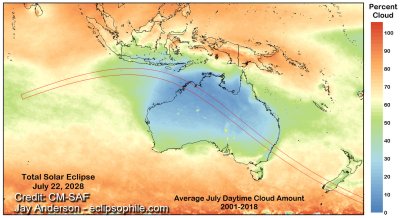
An excellent resource for eclipse weather is Jay Anderson’s eclipse weather website which has information on weather for the 2028 eclipse https://eclipsophile.com/future-eclipses-2024-2028/. Figure 7 is from that site and shows the mean July cloud cover as measured by satellite over an 18-year period together with the path of totality. The lowest cloud amounts are in northwestern Australia where there is an excellent probability of clear skies. The chance of cloud increases as the eclipse moves to the south-east but is still only at a moderate level towards the east coast.
Despite the encouraging statistics, there is always the possibility of cloud on the day.
Where to observe the 2028 total eclipse
To experience the total solar eclipse, you must be located on the path of totality. Anywhere outside the path of totality will only experience a partial eclipse. As the path of totality for this eclipse stretches from coast to coast there are many suitable locations for viewing. Here are some of the things you may consider when deciding where to observe from.
Weather prospects
Clear skies are essential for the best view of totality. The map of figure 7 shows that the best prospects for clear weather are in north-west Australia. However, there are also good prospects across central Australia and into western New South Wales. Chances of clear skies decrease closer to the east coast and into Sydney.
However, what is more important is the actual weather on the day of the eclipse. A good idea is to check on the weather forecast in advance of eclipse day. A good forecast of clear skies in one area can influence the choice of observing site. The Bureau of Meteorology forecasts can be consulted as well as international weather models. If there is consistency between the various models, then that will increase the confidence in the forecast.
If there is thin cloud at the time of the eclipse, then it will still be spectacular. If cloud cover is thicker then you may not see the dramatic sight of the Sun in total eclipse, but the sky will go very dark as the Moon’s shadow passes over. If there is cloud in the time before the eclipse, the temperature drop caused by the Moon’s shadow approaching may reduce the cloud cover in a phenomenon called “eclipse cooling”.
The totality experience
As long as the sky is clear the view of the eclipse from anywhere in the path of totality will be spectacular. However, the experience will vary depending on where you are in the path. Some people seek out the longest time in totality. The maximum duration of totality for this eclipse will be 5 minutes and 10 seconds on the centreline in the Kimberley area. The Greatest Eclipse Point is marked on Figure 3. East or west from here on the path of totality the duration will decrease but it is still a very creditable 3 minutes and 44 seconds in metropolitan Sydney. See how totality duration varies along the path of totality centreline in the animation of Figure 1.
The duration of totality will also vary depending on where across the path of totality you are. It will be a maximum in the area of the centreline but will still be significant across most of the path. Some experienced eclipse enthusiasts choose a location close to the edge of the path of totality. This will give a reduced time in totality but normally produces an enhanced experience of the transition effects at the start and end of totality with Baily’s Beads, diamond ring and chromosphere typically persisting for a longer time.
How far to travel
If you are lucky enough to live within the path of totality, then the best place to view totality is probably from home. You can invite family and friends and you have access to all facilities. If not in the path of totality, you can travel to the closest part of the path if the weather forecast for that area is favourable. Otherwise, you may need to travel to an area with a better forecast. If planning on travelling to the path in central Australia this can be remote country and you would be wise to be relatively self-sufficient carrying adequate fuel, food and water and allowing for contingencies.
If the weather for the area you have chosen to go to is uncertain with, for example, the possibility of cloud, there is benefit of being in an area where there are options to relocate in the day before or in the period leading up to the eclipse. A site that has a road that is aligned in the direction of the path of totality for example can be helpful if travelling in a vehicle or other similar method of transport.
Photography options
If photographing the eclipse against a great foreground is a priority, then there are many options to choose from for this eclipse. Some examples include Mitchell Falls and the gorges in the Kimberley region, Devils Marbles in the Northern Territory, outback areas in Northern Territory, Queensland or New South Wales and iconic locations in Sydney such as Sydney Harbour Bridge or the Opera House. For more information on eclipse photography see Eclipse Photography.
